River management
Causes of flooding
A flood occurs when a river bursts its banks and the water spills onto the An area of low-lying land next to a river which is prone to flooding..
The causes of Floods will happen when there is a temporary increase in the amount of water in the river. The water will overflow from the river channel onto the surrounding land (flood plain). are usually a result of both physical and human factors.
Physical factors are those which are caused by nature.
Human factors are when human intervention and interference create the conditions for flooding.
Physical causes
| Precipitation | The more rain that falls onto a drainage basin over a short period of time, the more likely that there will be some flooding in a river channel. Heavy or prolonged rainfall can lead to flooding. |
| Soil and rock | Different types of soil and rock will dictate whether the water flows through or stays close to the surface. Some soil or rock is impermeable, which means they do not allow water to infiltrate soil or percolate rock. Once soil and rock is saturated, or if it is impermeable, the water will become surface runoff and will run into river channels more quickly. |
| Land use | A drainage basin with little vegetation is more likely to flood quickly as there is no vegetation to intercept the water and remove it from the surface runoff. |
| Steep slopes | Areas where the drainage basin is small and valley sides are steep will return water to the river channel much more quickly than places where the slopes are gentler. |
Human causes
| Deforestation | Removing trees will reduce interception and increase the amount of water going into the river system. |
| River management | Sometimes measures taken to manage the river can increase the amount of water in the river. Putting concrete into a river to speed up the movement of water in one part of the river can cause flooding further downstream. |
| Global warming | As sea levels rise, there will be an increase in the amount of water available for evaporation and precipitation in the water cycle. This means that more water could be falling onto drainage basins than usual. |
| Urban growth | Impermeable concrete/tarmac roads and pipe/drain systems in urban areas can speed up the delivery of water back into the river channel making a flash flood more likely to occur. |
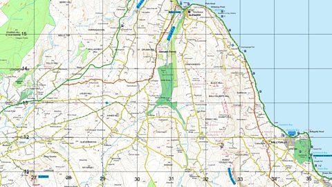
British Isles case study: Boscastle flood (2004)
Boscastle is a small coastal settlement in the south west of England.
It flooded in August 2004, washing cars and buildings into the sea and putting peoples' lives in danger.
Boscastle is at the Where two rivers meet and join together. of two rivers - the Valency and the Jordan.
A large quantity of water arrived within a short space of time causing the rivers to overflow.
The flooding coincided with a high tide, making the impact much worse.
| Physical causes of the Boscastle flood | Human causes of the Boscastle flood |
|---|---|
| Rain for 12 out of 14 days in August. | Many trees had been cut down for farming. This limited interception and water went straight into the river channel. |
| A depression brought a thunderstorm on 16 August with over 200mm of rain in 24 hours. | Increase in buildings within the drainage basin meant that there were more impermeable surfaces which directed water back to the river faster. |
| Steep valley sides - water flowed into the river channel very quickly. | A few old arch bridges got blocked up with the flood debris. The bridge acted like a dam and eventually smashed through causing a surge of water up to 3m high. |
| The rock in the local area is impermeable slate which does not allow percolation. | |
| The soils were quite thin and made up of impermeable peat soils. These became saturated so water became surface run-off very quickly | |
| There were very few trees to absorb water and slow the amount of water going into the river. |
The BBC's Fergus Walsh explains why the village of Boscastle in northern Cornwall flooded in 2004.
This is Boscastle as it normally looks. Keep your eyes on the bridge.
And this was Boscastle yesterday. So how was this torrent of water unleashed?
The north Cornish coast is used to flooding, even in summer, but the village of Boscastle was hit by a freak, highly localised weather event.
In the summer months, moist air from the sea comes in from both sides of the Cornish coast. Nothing unusual in that. Yesterday it formed rain clouds over Boscastle. These were monsters rising up to 40,000 feet.
Normally, high pressure prevents them ever getting that big. Then the rain started, and crucially, this weather system remained static for six hours, allowing nearly six inches of rain to fall over the village.
The geography of Boscastle made matters even worse. It is surrounded by hills and has two rivers which converge along its main street.
Here you can see the Rivers Valency and Jordan, which by yesterday afternoon had burst their banks.
Now if I turn the map round so that we can look upstream, you can see why the village was inundated.
The rainwater cascaded down the hills and added to the uncontrollable flow of water from the river.
The river, teeming with debris, may have got partially blocked as it flowed into the village, helping it burst its banks. Nothing, it seems, could have prevented it.
Against an event of this magnitude, I'm not sure at the moment that there's ever any way of preventing flooding when you have so much rain in such a short period of time.
An almost identical freak weather event happened 52 years ago to the day in Lynmouth on the North Devon coast. Again, two rivers which join in the village burst their banks after torrential rain. Thirty-four people died in that disaster, showing just how serious yesterday's deluge in Boscastle could have been.
Impact of flooding
Floods can cause damage to homes and possessions as well as disruption to communications. However, flooding can also have positive impacts on an area.
Flooding This takes place when the river load is too heavy for the river to carry and material is dumped (or deposited) within the river channel. fine silt (The sediment deposited by rivers. Also known as silt.) onto the An area of low-lying land next to a river which is prone to flooding., making it very fertile and excellent for agriculture. People living on or near floodplains may rely upon regular flooding to help support their farming and therefore provide food.
Less economically developed countries Less Economically Developed Country – usually a poorer country found in South America, Africa or Asia. tend to be affected more than more economically developed countries More Economically Developed Country – usually a rich country found in Western Europe or North America. by the effects of flooding.
This is partly because LEDCs have more farms, and farming communities are attracted to fertile flood plains. LEDCs often do not have the resources to prevent flooding or deal with the aftermath of flooding.
Impacts on people and the environment
| Impacts on people | Impacts on the environment |
|---|---|
| Loss of life: Floods can cause death and injury. People can get trapped in their houses by the quick rising waters. | Pollution: Floods will wash chemicals and sewage into the water. The contaminated water will spread quickly over an area – causing public health issues and killing fish. |
| Property: As flood waters rise they can flow into low-lying properties. The river will be carrying huge amounts of pollution and silt that will destroy floors, walls and any electrical gear. | Destruction of wildlife habitat: Floods will destroy places where river animals and fish might have breeding grounds. Even slight changes to river temperature and water patterns can upset natural ecosystems. |
| Insurance cover: Some people who live close to river courses find it difficult to get insurance whilst others cannot afford the insurance premiums. The cost of repairing and rebuilding damaged buildings can push up insurance premiums. | Water recharge: Floods can bring water back to dry areas (eg along the course of the river Nile in Egypt). Floods will ensure that there is water for irrigation or for drinking water in dry places. |
Flood management methods
Steps can be taken to manage flooding. This is known as These are techniques/ methods that are used to reduce the likelihood of flooding and damage due to flooding.. Often these steps involve trying to lengthen the amount of time it takes for water to reach the river channel, thereby increasing the lag time. Rivers can be managed by using hard or soft engineering.
Hard engineering is when construction is used to prevent the risk of flooding. When a river is managed in such a way so that it needs major building work to stop the river from flooding. Usually machinery and concrete/ building materials are used. tend to be more expensive and have a greater impact on the river and the surrounding landscape. They will require more extensive alterations to the river to try to stop flooding.
Soft engineering is where natural methods are used to reduce the risk of flooding. When a river is managed in such a way so that it needs limited building work and floods are more prevented than managed. These measures are usually more sustainable than hard engineering methods. are usually more ecologically sensitive. They will attempt to manage flood rather than prevent it.
Hard engineering
Soft engineering
CASE STUDY: The Mississippi River, USA
In the summer of 1993, the Mississippi, one of the most heavily engineered rivers in the world, burst its control banks in one of the most devastating floods to hit the USA.
This event brought to a head a question that had been smouldering for a very long time. Can big rivers like the Mississippi ever be completely tamed? Or will nature always somehow take its course?
The Mississippi is over 3,000 kilometres long, draining half of the United States. It is the major river artery of America.
Three hundred years ago, before Europeans arrived, the landscape in the valley was a wetland measuring 100 kilometres from east to west, across which the river wandered at random. During periods of really heavy rain, the river burst its banks, turning the floodplain into a lake. When the rain stopped, the river would often return to a completely different route from the one it had taken before. This was a nightmare for shipping.
The average paddle steamer only lasted 18 months before crashing. Without a reliable shipping channel, the transport of farm and factory products was chaotic, the valley's economy in dire straits. Something had to be done.
It was the Army engineers who took on the huge task. Their first move was to build what are known as wing dykes out into the river. Built from tough stone, they trapped large amounts of the river's sediment, forming new land which narrowed the channel down.
What happened is what the engineers had predicted. Forced into a narrower width, the river flowed faster and eroded a deeper channel. A much better bet for shipping.
But this didn't solve the flooding problem. Every spring, as the winter snows melted, the river did what it had always done.
If agriculture, cities and industries were to grow successfully next to the river, another idea was needed.
This time, what the engineers did was literally wall the river in. These walls, known as levees, were built along the whole length of the river, eventually offering better protecting to riverside developments.
But as the population grew, the engineers came under huge pressure to make sure that flooding would never ever again be a threat to people and property. At that point, they really went for it.
First, control dams were built to hold back floodwater and reduce pressure on the levees. Second, they changed the map of the valley. Shortcuts were blasted through the numerous meanders. Water was speeded more smoothly downstream. The natural course of the river dried up. By the time they'd finished, the Mississippi was 250 kilometres shorter.
Third, and finally, the riverbanks were stabilised with mattresses of concrete slabs.
It's taken 100 years and £7 billion to change the whole look of the Mississippi river landscape.
Then, in the late spring of 1993, the weather over the Mississippi basin went mad. The border between warm air from the Gulf of Mexico and cold air from the Arctic became stuck 2,000 kilometres farther south than normal. Along this crucial junction, it rained for weeks on end.
The result was a massive increase in the volume of water in the river. Water that, in the river's natural state, would have spread sideways was hemmed in, trapped between the levees, leading to a frightening build-up in pressure. The river didn't like it. In the end, the levees gave up under the sheer weight of water.
Having more or less protected the riverside areas from the Mississippi's average behaviour, the engineering could not ultimately cope with nature at its most extreme.
The lesson from 1993 is that the Mississippi will probably do the same thing again. The threat of flooding will not go away.
But how could anybody ever say, "You can't build here"?
The Mississippi Rivers drainage basin covers 3 million km², half the land area of the United States of America. That is ten times the size of the UK and Ireland combined.
The river network flows south to the Gulf of Mexico where it has formed a 150km wide floodplain. Such low lying, fertile land is very attractive for agriculture, transport and human settlement.
Under natural conditions, heavy rainfall between January and April combine with spring snow melt to cause the Mississippi to flood.
To use the river and build settlements along its banks, the US Corps of Engineers has been working for over 120 years to tame or control the Mississippi. The river no longer floods annually but the devastating flood in 1993 and a smaller event in 2022 showed that, despite their efforts, flooding is still a risk.
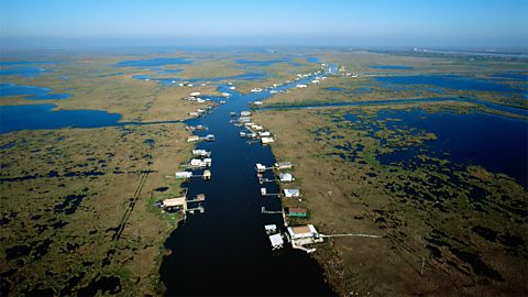
Many engineering strategies have been attempted along the Mississippi, while some are designed to maintain a safe route for boats and barges most address the flooding problem.
Hard engineering on the Mississippi
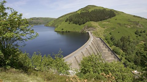
There are 27 large dams on the Upper Mississippi River and over 100 dams constructed along its tributaries, including the Missouri, Tennessee and Ohio rivers.
One key aim of these is to store floodwater in their reservoirs during times of high discharge.
The sustainability of dams and reservoirs
| Positives |
|---|
| The reservoirs have the capacity to prevent the ‘normal’ annual river floods. Therefore, they protect over 20 million people living further downstream. |
| Many dams also produce hydroelectricity, a source of ‘green’ energy and the water storage in reservoirs ensures a reliable water supply for the domestic and agricultural needs of nearly 20 million people. |
| Negatives |
|---|
| Dams are expensive to build and maintain. In the State of Mississippi itself, dam repairs cost $40 million. |
| While designed to trap floodwater, dams also trap silt. This means clear water erosion is increased and the silt supply to the delta has been reduced. This can cause coastal erosion and the loss of habitat. Numbers of delta wildlife, including herons have fallen dramatically. |
| Formerly, river silt was spread as alluvium across the river’s floodplain. This no longer happens, so expensive additional fertiliser is now needed to enrich the farmland soils. |
Levees
These artificially raised earth banks have been constructed since the 1930s and today they are 15m in height and extend for over 3000km of the river’s banks.
Floodwalls
In riverside cities, such as St Louis, the levees are often replaced by floodwalls, which use less land.
The sustainability of levees and floodwalls
| Positives |
|---|
| Levees have reduced the number of flood incidents dramatically. |
| Development of farmland on the floodplain has been made possible. Towns and cities have developed along the river and on its floodplain. Around 70 million people live in the Mississippi basin, that’s 20% of the population of the USA. |
| Negatives |
|---|
| Levees are expensive both to construct and maintain, especially on the scale of this river with 3000km of riverbank. |
| By trapping silt in the river, the riverbed has been raised above the floodplain. In New Orleans the riverbed is 4.3m (as high as a two-storey house) above the city. So, when the levees fail the floodwater flow can be devastating, as seen in the 2011 event. |
| While levees do prevent floods where they are built, they can push floodwater downstream to unprotected areas, which then flood. |
| By preventing floods levees also prevent alluvium from spreading across the floodplain, leading to the need for expensive fertiliser to maintain the soil for agriculture. |
Soft engineering on the Mississippi
Planning legislation has been used to restrict building development on areas of the flood plain. Sometimes the land, at risk of flooding has been bought by government.
An example is Rock Island, Illinois which the US Conservation Service purchased for $25 million.
The sustainability of land use zoning
| Positives |
|---|
| This prevents the construction of property in flood risk zones. |
| The return of land to its natural state such as wetlands has no negative environmental impact. |
| Little to no maintenance is required. |
| Negatives |
|---|
| The initial cost of buying land or compensating property owners may be high. |
Afforestation
Large scale tree planting across the catchment area of the Mississippi river’s tributaries aims to reduce and slow down runoff. From 1933-53 over 240 million tree seedlings were planted in the Tennessee River Valley, trees reach maturity in 20 to 40 years. Today, the forest covers 5.7 million hectares, over half of the Tennessee Valley’s drainage basin area.
The sustainability afforestation
| Positives |
|---|
| The trees, through the natural processes of interception and uptake, have reduced the amount of water reaching the river. |
| Forests require little maintenance, but properly managed they are a valuable economic resource. |
| Negatives |
|---|
| To make a significant impact a large-scale programme is needed and it takes decades for trees to be mature enough to have a significant impact. |
Washlands and spillways
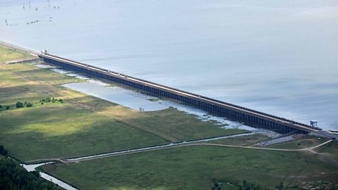
Spillways are designed to redirect floodwater away from the Mississippi main river channel, to be temporarily stored on designated areas of the floodplain (Washlands).
The Morganza Spillway, Louisiana has 125 opening gates through which up to half of the river’s discharge can be redirected onto low density populated farmland.
The sustainability of washlands and spillways
| Positives |
|---|
| The Morganza Spillway was opened during the 2011 extreme event, over 12 000km² of farmland was deliberately flooded. This action prevented millions of dollars of property damage in the city of New Orleans further downstream. |
| After the initial expense maintenance costs are low. |
| Negatives |
|---|
| Use of the washland requires the mass evacuation of people and livestock and the swamping of any crops being grown. Farmers must be compensated for their losses. |
Sustainable development
The United Nations have defined sustainability in 1987 as,
Development that meets the needs of the present without compromising the ability of future generations to meet their own needs.
An evaluation that refers to the principles of sustainable development needs to consider the social, environmental and economic impacts that each management strategy might have.
Social impacts refer to how a management method will affect people. It will look at how it impacts their houses and where they live, how it will affect their daily lives and their food and water supply.
Environmental impacts refer to how management methods will impact the natural environment. How will any development affect animals and plant life in the local area? How will it impact water quality and sewage?
Economic impacts refer to how the management methods used will affect how people work. How will this affect jobs and income? Will the measure make people richer or poorer – will it have a positive or negative impact on their livelihood?
Test yourself
More on River environments
Find out more by working through a topic
- count1 of 5
- count2 of 5
- count3 of 5
- count4 of 5