How does a river change from its upper course to lower course?
A river's features will change as it moves from the The highest section of a river located in the mountains. to the The final section of a river located on flat land..
| Stage | Main activity | Main features |
|---|---|---|
| Upper course (steep gradient) | Vertical (downward) erosion | Source, tributaries, waterfalls, gorges |
| Middle course (gentle gradient) | Lateral (sideways) erosion starts, transportation | Slip-off slopes, meanders, river cliffs |
| Lower course (very low gradient) | Deposition | Floodplains, levées |
In the upper course, river features include A vertical cliff of water where the water flows over a layer of hard rock on top of a layer of softer rock. The softer rock is eroded away causing the cliff edge to gradually move backwards. and gorges.
How is a waterfall formed?
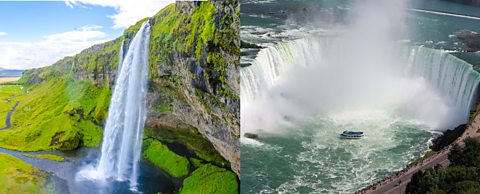
A vertical cliff of water where the water flows over a layer of hard rock on top of a layer of softer rock. The softer rock is eroded away causing the cliff edge to gradually move backwards. can usually be found in the upper and middle course of a river.
They are found when a river runs over alternating layers of hard and soft rock.
As the water moves over the hard rock it will be able to erode any exposed softer rock.
The This takes places when parts of the river bank or river bed are worn away and are removed from the landscape. processes of When the force and speed of the water dislodges material from the river bed and banks (erosion)., When stones being carried by the river are thrown against the bed and banks of the river and grind against the surface to wear it down (erosion). and When stones being carried by the river knock against each other and start to wear each other down (erosion). will work together to erode the rock – causing the waterfall to start to retreat and leave a steep-sided gorge.
The formation of waterfalls
Narrator:
Attention visitors if you've lost a jumper, please come to the cold front.
Welcome one and all to Waterfalls.
As a river moves from an area of hard rock to an area of softer rock. Hydraulic action, abrasion and attrition all help erode the soft rock below.
As you can see this first waterfall is relatively small, but as we go over the edge the speed of the water increases due to lack of friction.
Erosion occurs in the soft rock below due to the force of the water.
Our second waterfall is a little steeper and deeper and the hydraulic action of the water has eroded the soft rock to create a plunge pool. Excellent.
Now for our third waterfall as the soft rock becomes further eroded an overhang is created.
And with further erosion cracks may begin to form.
Now for our fourth and final waterfall.
If too many cracks appear in the overhang the rock will eventually break and fall into the river below.
The eroded material is then transported through the river system.
The cliff face recedes and the waterfall moves upstream, creating a steep sided gorge. You have successfully completed Waterfalls.
We hope to see you again soon.
What is a meander?
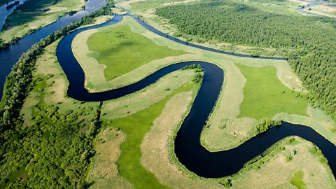
In the middle course the river has more energy and a high volume of water. The The angle of the land - as the river flows towards the mouth, it will become less steep and therefore the land will be flatter. here is gentle and lateral (sideways) This takes places when parts of the river bank or river bed are worn away and are removed from the landscape. has widened the river channel.
The river channel has also deepened. A larger river channel means there is less friction, so the water flows faster.
As the river erodes laterally, to the right side then the left side, it forms large bends, and then horseshoe-like loops called In the middle and lower course of the river, a river bend will form as the faster flow of the river towards the outside of the bend causes erosion. The slower flow on the inside of the bend will cause deposition..
The formation of meanders is due to both This takes place when the river load is too heavy for the river to carry and material is dumped (or deposited) within the river channel. and erosion and meanders gradually migrate downstream.
The force of the water erodes and undercuts the river bank on the outside of the bend where water flow has most energy due to decreased friction. This will form a river cliff.
On the inside of each bend, as there is more friction, the river flow is slower and material is deposited. This forms a Gently sloping bank found on the inside of a river bend because of slow-flowing water, depositing sediment..
Over time the horseshoe becomes tighter, until the ends become very close together.
Meander cross section
How are floodplains and levees formed?
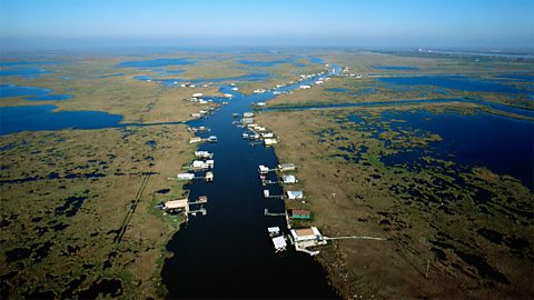
In the lower course, the river has a high volume and a large discharge. The river channel is now deep and wide and the landscape around it is flat.
Floodplains
The river will now have a wide An area of low-lying land next to a river which is prone to flooding..
A floodplain is the area around a river that is covered in times of flood. This is a large, flat area of land that is formed by erosion and deposition.
Firstly, erosion at the outer bends of a meander will gradually wear away and flatten the land on either side of the channel.
Secondly, when the river overflows its banks, during a flood, the water will leave the channel and flow over the land.
The floodwater will lose energy, slow down and deposit its sediment load. This deposited sediment is known as alluvium.
The floodplain is often a very fertile area due to the rich alluvium deposited by floodwaters. This makes floodplains a good place for agriculture.
Every time that a river floods its banks, it will deposit more silt or alluvium on the flood plain. Over time, the flood plain will become wider due to erosion and deeper due to deposition.
A build-up of alluvium on the banks of a river can create A buildup of alluvium on the banks of a river which will raise the river bank due to the repeated flooding of the river. The biggest, coarsest material will be dumped close to the river bank., which raise the river bank.
Levees
A levee is a raised bank formed on the banks of a river, in the lower course.
Levees are formed by the repeated Floods will happen when there is a temporary increase in the amount of water in the river. The water will overflow from the river channel onto the surrounding land (flood plain). of the river. When the river floods, during periods of high energy, the water and the load it is carrying will leave the channel.
Due to the drop in energy caused by friction, the biggest, most coarse material will be dumped close to the river banks. With repeated flooding, this will continue to build up the levee over time.
Test yourself
More on River environments
Find out more by working through a topic
- count4 of 5
- count5 of 5
- count1 of 5
- count2 of 5